How NASA, Microsoft, and the EU accelerate earthquake rescue with AI
Published by AINave Editorial • Reviewed by Ramit
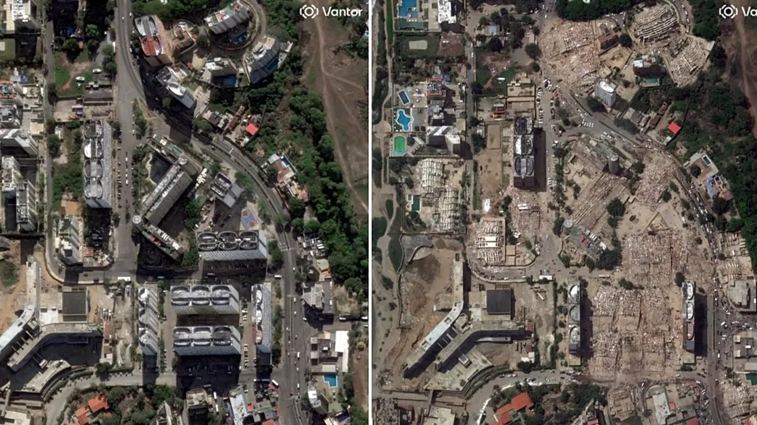
Rescue teams responding to the twin earthquakes that struck Venezuela are getting help from space. NASA, Microsoft, and the European Union have activated a network of satellite sensors and machine-learning models to map damaged areas within hours, guiding emergency resources to neighborhoods most likely to need them.
The effort shows how AI-assisted disaster response can work in practice. But the tools provide probabilistic estimates, not definitive diagnoses. Ground inspections remain essential.
What happened
NASA activated its disaster response program with researchers at Oregon State University to analyze radar images captured before and after the quake. By detecting abrupt changes in the ground and buildings, they estimated that nearly 59,000 buildings may have been damaged or destroyed. (A separate CNN report cited a figure of approximately 58,870 buildings.)
The raw data comes from the European Copernicus program. Sentinel-1 satellites, operated by the European Union and the European Space Agency, supply high-resolution radar imagery that can measure ground movements of just a few centimeters and spot buildings whose shape has changed. That imagery is the foundation for the AI analysis.
Microsoft's AI for Good lab built computer-vision models that automatically classify thousands of satellite images by the likelihood of damage. The models highlight which neighborhoods should be inspected first, complementing ground teams rather than replacing them.
All this information flows through the United Nations Centre for Humanitarian Data (HDX), where Microsoft publishes the damage maps. Governments, NGOs, and rescue teams can consult the maps almost in real time, coordinating from a shared view of the disaster.
Why AI builders should care
This is a real-world example of AI systems working within operational constraints. The models deliver probabilistic estimates, not ground truth. Every classification is a signal to prioritize, not a final verdict. Builders working on emergency response or geospatial AI should note the importance of ground-truth verification and designing systems that augment human decision-making rather than attempt to replace it.
The architecture also demonstrates how interoperable data platforms can scale. HDX acts as a single source of truth, while satellite operators (Copernicus), AI labs (Microsoft AI for Good), and research institutions (Oregon State University) each contribute specialized capabilities. This modular approach is relevant for any multi-stakeholder AI deployment.
Practical implications
For emergency managers, the value is speed. Mapping tens of thousands of buildings by conventional aerial survey or foot patrol can take days. AI models can return damage probabilities within hours, letting rescue teams focus on the most affected zones first. When every hour counts in the search for survivors, an almost instant snapshot of the disaster can shift priorities fast.
For AI builders and developers, the key takeaway is integration. The successful deployment depended on moving model outputs into a platform that multiple organizations already used (HDX). Building for existing workflows, not standalone dashboards, made the difference between a research output and an operational tool.
Caveats
The damage maps are probabilistic. Experts stress that AI outputs do not replace on-the-ground inspection or local knowledge. Satellite coverage depends on satellite revisit times and weather conditions. Radar can penetrate clouds, but optical images may be delayed in persistent cloud cover.
Finally, this system was activated for a specific event with dedicated resources from NASA, Microsoft, and the EU. Scaling such a response to more frequent or simultaneous disasters would require sustained infrastructure investment.
Comparison of key roles in the response
| Organization | Role | Key Output |
|---|---|---|
| NASA / Oregon State University | Radar image analysis | ~59,000 building damage estimate |
| Copernicus (EU/ESA) | Satellite radar data | Sentinel-1 high-resolution ground movement imagery |
| Microsoft AI for Good | Computer-vision classification | Damage-likelihood maps for neighborhoods |
| UN HDX | Data platform | Near real-time shared damage maps |
FAQs
How is AI used to speed up post-quake rescues in Venezuela?
AI analyzes satellite radar imagery from before and after the quake to identify buildings with a high probability of damage. These probabilistic estimates help rescue teams prioritize which neighborhoods to inspect first, accelerating response without replacing on-site verification.
What role do NASA and Microsoft play in the disaster response?
NASA activated its disaster response program with Oregon State University to analyze radar images and estimate building damage. Microsoft's AI for Good lab developed computer-vision models to classify buildings by damage likelihood, helping prioritize where ground teams should go.
What is Copernicus Sentinel-1 and how is it used in this context?
Copernicus Sentinel-1 satellites provide high-resolution radar imagery that can detect ground movements of a few centimeters and changes in building shapes after an earthquake. This data is the raw material for AI damage assessments.
Do AI assessments replace on-site inspections or complement them?
They complement them. AI maps provide probabilistic estimates, not definitive diagnoses. Ground inspections and local knowledge are still required to confirm damage and guide rescue operations.
Sources
- How NASA, Microsoft and the EU use AI to speed up post-quake rescues in Venezuela
- How NASA, Microsoft and the EU use AI to speed up post-quake...
- Venezuela Earthquake Destruction Revealed in New Satellite... | WIRED
- Google News - Rescuers find survivors in rubble days after Venezuela...
- Venezuelans in Florida Rush Earthquake Aid to Quake-Hit... - YouTube
- Venezuela: Death toll nears 2,000 as rescue hopes fade
- How NASA, Microsoft and the EU use AI to speed up post-quake rescues in Venezuela
- ImRobot on X: "Recently we had an earthquake that mostly affected northern Venezuela. There are a lot of people helping right now. Within that help, a lot of tech enthusiasts & vibecoders rushed to create help portals, & that's good. The only issue is that information is scattered across https://t.co/LZAFWrwymM" / X
- June 29, 2026 - Venezuela earthquake death toll passes 1,700, miraculous rescues offer hope | CNN
- Responding to Venezuela Earthquakes - United States Department of State
- Venezuela earthquakes: International rescue teams join the search for survivors as death toll surpasses 1,400 | UN News
- How to help survivors of the earthquakes in Venezuela | The IRC
- How NASA, Microsoft and the EU use AI to speed up post-quake rescues in Venezuela
- NASA
- Venezuela: Two-year-old rescued and taken to hospital six days after...
- Praying for Rescues as Hope Fades After Venezuela’s Double Quake
Latest Tech News