AI for crisis resilience: how Google's multi-hazard forecasting and humanitarian tooling empower builders
Published by AINave Editorial • Reviewed by Ramit
Google and the United Nations have released a joint framework on using AI to enhance multi-hazard early warning systems. The initiative spans forecasting, real-time alerting, and post-disaster damage assessment, with tools already deployed during the 2025 hurricane season and in flood-prone regions across Africa. For AI builders, the key takeaway is a set of open datasets, interoperable alerting protocols, and hybrid forecasting models that can be integrated into crisis response workflows.
What happened
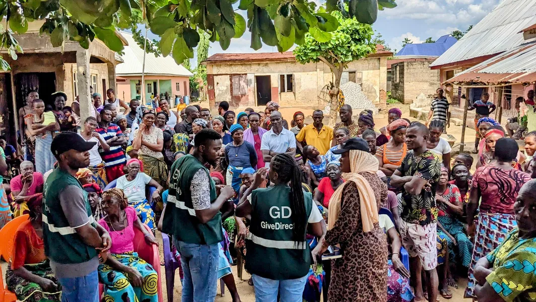
The UN report "Leveraging AI to enhance multi-hazard early warning systems" details how Google's AI breakthroughs are being used by governments and humanitarian organizations. During the 2025 hurricane season, the U.S. National Hurricane Center used Google's WeatherNext model, which predicted Hurricane Melissa's historic Jamaican landfall five days in advance. In Nigeria's Adamawa state, UN OCHA launched a Floods Anticipatory Action Programme using Google's river flood forecasts to trigger early interventions like shelter preparation. The NGO GiveDirectly used similar forecasts in Kogi State to deliver cash transfers before flooding.
Google's Flood Hub now covers 2 billion people across more than 150 countries. A pilot with the World Meteorological Organization and national hydrological agencies in Czechia, Nigeria, Uruguay, and Vietnam found that incorporating local streamflow data into global AI models significantly improves forecasts in ungauged areas. Google also open-sourced its Groundsource dataset for urban flash floods and its hydrology modeling framework.
For wildfires, Google developed the FireSat satellite constellation with the Earth Fire Alliance and Muon Space. Three new FireSat satellites launched from Vandenberg Space Force Base. On the alerting side, CAP-based Public Alerts surface warnings from authorities in over 90 countries across Search, Maps, and Android notifications.
Post-disaster, the DISHA damage assessment workflow has been deployed 11 times with UNOSAT. After Hurricane Melissa, it assigned preliminary damage scores to over 385,000 buildings. Following February 2026 floods in Colombia, UNOSAT cross-referenced AI-derived building maps with radar imagery to inform response planning.
Why AI builders should care
For teams building crisis response or geospatial AI products, this initiative demonstrates several patterns worth adopting. First, hybrid forecasting models that blend global AI with local data can improve accuracy in data-sparse regions. The WMO pilot provides a blueprint for how to integrate national hydrological data into global models without losing local control.
Second, the open-sourcing of Groundsource and the hydrology framework means developers can build on Google's work while retaining full ownership of their own data. The Czech Hydrometeorological Institute already built an adapter to use the model in standard workflows.
Third, the Common Alerting Protocol (CAP) integration shows how AI-generated warnings can reach billions through existing distribution channels. Any builder creating a public safety app can tap into these CAP feeds or replicate the pattern for other alert types.
Practical implications
Developers can explore several concrete integrations:
- Data pipelines: Combine satellite imagery, Open Buildings datasets, and local hydrological data to build risk assessment tools. The DISHA workflow shows how to scale building damage analysis from weeks to hours.
- Alerting APIs: CAP feeds are standardized and already used by 90+ countries. Your app can surface these alerts via Search, Maps, or push notifications without building custom ingestion for each authority.
- Open models: The hydrology framework and Groundsource dataset are available for experimentation. If you work with urban flood modeling, these can accelerate your research while keeping local data private.
- Hybrid forecasting: If you operate in ungauged regions, consider combining global AI forecasts with sparse local measurements. The WMO pilot results (to be published soon) will offer more detail on the accuracy gains.
Caveats
The plans and deployments reflect ongoing collaborations and pilots; results may evolve as programs expand. Some outcomes, such as the precise effectiveness of forecasts in all ungauged regions, depend on data quality, local governance, and partner engagement. Not all regions have CAP feeds or wide mobile reach, which can limit alert dissemination in certain contexts. Builders should also note that the FireSat constellation is still in early deployment, and the full wildfire detection capabilities will take time to materialize.
FAQs
What is AI for crisis resilience and how is it used by governments and organizations?
AI for crisis resilience refers to using machine learning models to predict natural hazards, issue early warnings, and assess post-disaster damage. Google and the UN have published a joint framework that includes tools like WeatherNext for hurricane forecasting, Flood Hub for river flood predictions, and DISHA for satellite-based damage assessment. These tools help governments and humanitarian organizations take pre-disaster action and coordinate response more efficiently. Source
How does Google's WeatherNext improve hurricane forecasting and disaster response?
WeatherNext is an AI model that provides longer lead times for hurricane forecasts. During the 2025 season, it predicted Hurricane Melissa's landfall in Jamaica five days in advance, giving authorities time to issue public warnings and prepare shelters. The U.S. National Hurricane Center used the model to support its operational forecasts. Source
What is the Floods Anticipatory Action Programme and the Flood Hub?
The Floods Anticipatory Action Programme, run by UN OCHA in Nigeria, uses Google's river flood forecasts to trigger early interventions like shelter preparation and cash transfers before flooding occurs. Flood Hub is Google's platform that provides flood forecasts covering 2 billion people across more than 150 countries. It combines global AI models with local streamflow data to improve accuracy in ungauged regions. Source
What are CAP-based Public Alerts and how are they delivered to users?
CAP-based Public Alerts are warnings issued by authorized agencies using the Common Alerting Protocol. Google surfaces these alerts in Search, Maps, and as Android notifications. The system currently includes data from authorities in over 90 countries, such as the U.S. National Weather Service, the UK Met Office, and Brazil's CENAD. This ensures critical safety information reaches people quickly through the devices they already use. Source
Sources
- How governments and organizations are leveraging Google’s AI breakthroughs for crisis resilience
- Google LLC (via Public) / How governments and organizations ...
- Google AI for Public Sector 2024: Innovations Transforming ...
- Crisis Resilience | Partnerships
- How governments and organizations are leveraging Google’s AI ...
- AI Breakthrough Tackles Energy Crisis with 100× Efficiency and Smarter Neuro Symbolic Robots Puzzle Solving Gains
- How Cyber Resilience Helps Governments Harness AI Infrastructure
- From research to climate resilience
- Global SSA Market to Reach $61B as Governments Prioritize Space Security, Resilience, and Orbital Safety
- ‘No time to waste’ in prepping governments for AI cyber threats, top Dem lawmaker says
- AI could fuel severe cyberattacks against governments, businesses within months, Five Eyes spy agencies warn
- Anthropic’s Dario Amodei wants governments to have the power to block ‘dangerous’ AI systems